In the Torfajökull area the landscape divides in two. The eastern area is carved out by gullies where Jökulgilskvísl is. It runs on gravel flats, as do some of the main tributaries that join it, but the side gullies are narrow at the bottom, loose landslides above and rock when higher up one comes. The gravel flats have come about through lava dams in Tungná and most recently in Jökulgilskvísl itself, when Norðurnámshraun dammed it a little over 500 years ago. The tributary had as a result to build up under itself.
Geothermal heat and geothermal signs in the Torfajökull area cover an area of about 200 km2. The core of the active geothermal heat is in an enormous caldera and covers about 100 km2, but alteration in the rock reaches far beyond it, and outflow water appears in low areas outside the mountain massif, mainly on the south side.
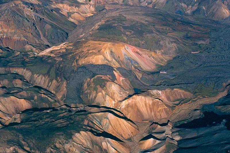
Fracture and volcanic activity reaches into the eastern area at its very northernmost with NE-SW-trending fractures and the eruption fissure of Laugahraun. The eastern area is characterised by colourful rock in steep terrain but dark tuff and tephra where a plateau takes over above the gullies.
Most of the western area is an undulating plateau with shallow valley draws. Markarfljót runs west off it and takes up small rivers and streams from Reykjadalir, yet is still small at the ford north of Laufafell. The only considerable eroded area is in Ljósártungur. There quite deep gullies have been carved into the caldera fill inside the caldera rim and reach north below Hrafntinnusker and east to Kaldaklofsjökull. Dalakvísl, which runs to the north, has come some way in carving itself in from the caldera margin on that side, but progresses slowly because there is a short distance to an eruption area with tuff and young lavas that hinder it. To look over, the western area is dark, with steam plumes and green stripes where it is moist. The dark colour is caused mostly by the youngest eruptive tephra (Hekla 1845 and 1597, plus Katla 1918). Where it is carved into, thick pumice layers are also seen. The youngest of them is from Hrafntinnuhraun. It lies thick on the ridges north-west of the lava and gives them a grey colour where the black tephra has been blown off.
The geothermal heat is mainly in seven clusters, named after Landmannalaugar, Hattver, Háuhverir, Stórihver, Vestur- and Austur-Reykjadalir and Ljósártungur. Geothermal heat also occurs outside them, but is insignificant. Mention was made above of outflow outside the main core (Dalakofi, Laufafell, Grashagi, Bratthálskvísl, Strútslaug and Dómadalur).
The Landmannalaugar cluster reaches in through Vondugil, Grænagil and Brandsgil. The land height is 600-900 m. The springs are mainly steam and mud pots, nowhere very powerful, and sometimes follow NE-SW-trending fractures. In a few places extinct springs can be seen lining up on fractures with the same trend, but then high up in the land (Tröllhöfði, and between the Brandsgil gullies). Hydrothermal explosion craters are seen in several places, for example at Laugavegur. Springs with deep-water characteristics (chloride- and silica-rich water) also occur on the gravel flats where it is lowest. No considerable deposits are seen, however. The rock formations are extremely varied in this area, and excess in colours and landscape.
The Hattver cluster covers rather insignificant geothermal areas at the top of Stóra-Brandsgil and down along Suðurskalli, down into Hattver and into the basins opposite Hattver south of "Kvíslin". All of these are steam and mud pots, but pool temperatures in Hattver. Calcareous pools with ornate algal growth and depositional terraced rims are in Hraukagil east of Skalli.
The Háuhverir cluster, about 7 km² in size, is east of Reykjafjöll and stretches from there down into Kaldaklof and Heitaklof and from there up below Torfajökull. Spring activity is at 700-900 m height, in many places continuous and intense, all steam and mud pots. It is most difficult to get about this area, but access is easy if one drives in to the bottom of Jökulgil, likewise if one walks east of Reykjafjöll, or up out of Kaldaklof to the south. From Skalli and Suðurskalli there is a unique view over the inner part of Jökulgil with its countless side gullies and colourful rock, and over the geothermal areas and the small glaciers nestling north in the high mountains around. Contrasts wherever one looks: gully land - plateau, colourfulness in the gullies and monotone dark tephra and tuff above, springs - glaciers, vegetated rock slides and barren mountain landslides and gravel flats.
The Stórihver cluster is a single, isolated geothermal area in the easternmost draws of Markarfljót at 900 m height and small in extent. There is intense spring activity there, and the steam plume from Stórihver is generally visible from afar. Thirty years ago it hissed so loudly that it was unpleasant to stand nearby, but that is no longer so. Water-rich warm springs come from a lava cove directly opposite the spring. The spring cluster is connected to NE-SW faults that run into and in under Hrafntinnusker, and the same applies to cold geothermal patches and pools in a gully draw somewhat farther north. Laugavegur runs by Stórihver, and an old vehicle track ends on the gravel a short way north of the spring. The surroundings are rather monotonous there around.
The spring cluster in Vestur-Reykjadalir is about 4 km² in area at 800-900 m height and reaches from Dalamót up into Dalöldur to the west of it. The springs are in hollows and gully gorges, with thermal patches around. Among them are powerful steam vents, mud pots, boiling pans and murky water pits. Hydrothermal explosion craters occur (Fífuhvammur). Dalöldur are of tuff, but rhyolite in the substratum appears in the deepest gully north of the vehicle track. The geothermal area is almost all north of Markarfljót. South of it are lavas and pumice and no geothermal heat visible until one comes south of Hrafntinnuhraun.
Austur-Reykjadalir (Hrafntinnusker). There are no sharp boundaries between Austur-Reykjadalir and Ljósártungur other than that in Ljósártungur the geothermal heat is in a very gullied area, while in Austur-Reykjadalir it is more level. Outside the lavas there are gently sloping, pumice-covered domes and gorges rather than gullies branching up into them to the watershed that runs over Jónsvarða south-west of Hrafntinnusker. The geothermal area in Austur-Reykjadalir is at 850-1000 m height and covers an area of about 10 km². Just under half of it is in the oldest lavas, Sléttahraun and Hrafntinnusker, the other part south-west of them. There is tuff beneath, but rhyolite in the hills farthest west. Spring activity there is unusually great and continuous, with steam, mud and murky water springs. It is greatest on the slope up to Jónsvarða, around the eruption fissure of the Hrafntinnusker lavas, and there are the most powerful springs. Great spring activity and thermal patches are also around the vents in Sléttahraun and south-west from there. In addition to eruption fissures in the rhyolite lavas, faults and tuff ridges trend from the north-east into the geothermal area. The attraction of the area is the springs, first and foremost the ice caves at the southernmost part of the glacier mound north-west below the high sker. Water-rich springs, some warm, spring out from beneath the Hrafntinnusker lava. Into the streams from them a great deal of tephra and pumice is carried during floods when outflow from above the lava is added.
Ljósártungur. The geothermal area in Ljósártungur is at 850-1000 m height and about 10 km² in size. It is for the greatest part in the gullies that run to Ljósá and in Ljósárgil itself, but also reaches down into Jökultungur far inside. The spring activity is greatest south below Hrafntinnusker and west below Jónsvarða, and some of the springs yield little to the largest ones there north below. All of these are steam and mud pots with thermal patches around and large expanses, bleached by alteration but cold. Tuff ridges trend from the north-east into the geothermal area in Ljósártungur, and basalt dykes with the same trend are seen there in the gullies. Laugavegur runs along this area on the east, and it is a short walk from the ice caves south to the main geothermal area south of Jónsvarða and the Sker. The landscape and rock formations are particularly varied there. Rhyolite, ancient caldera fill, is dominant down in the gullies, but younger domes above. Also remarkable is a large pumice stack south-east below Hrafntinnusker, formed at the start of the eruption there.
Ideas about a power station have mainly focused on Austur- and Vestur-Reykjadalir, though much more on Austur-Reykjadalir (the Hrafntinnusker area), since it is larger and the activity there much greater. The Stórihver area also lies well for a power station. The other areas counted here would come less into consideration for conservation reasons, and some because of poor access.
Source: Kristján Sæmundsson, ÍSOR.