The work has consisted, among other things, of:
- building a database on the Icelandic continental shelf
- providing advice on interpreting survey data with respect to probable resources
- assessing where there is a likelihood of finding oil and gas reserves
Database on the Icelandic continental shelf
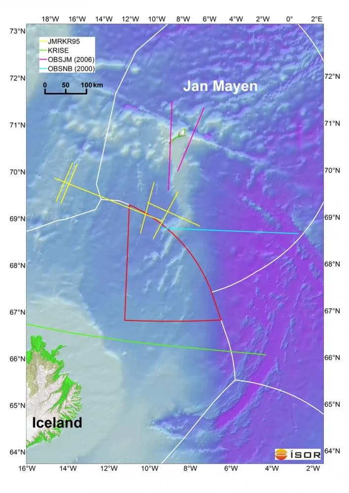
The database contains data relating to the Icelandic continental shelf. These are overview data on the seabed and information on research expeditions, in particular seismic reflection surveys and multibeam surveys. In total, about 1100 maps, cross-sections and other paper documents are registered in the database, about half of them in digital form. The data date from around the middle of the 20th century. Some of the data have been georeferenced and vectorised. The data are mainly from the Dreki area to the east and northeast of the country. The work was carried out in collaboration with and for the National Energy Authority (Orkustofnun).
A large part of the data was published in the so-called Continental Shelf Web Atlas (Landgrunnsvefsjá) (accessible until the year 2019). The Continental Shelf Web Atlas was an information service on the licence areas for licences for the exploration and production of hydrocarbons.
Research data
- seismic reflection surveys
- sediment studies
- multibeam surveys
- gravity surveys
- magnetic surveys
- seismic refraction surveys
- bottom samples
Interpretation of data
- Resource assessment for hydrocarbon exploration
ÍSOR has provided the Icelandic authorities with expert advice on possible hydrocarbon resources and promising exploration areas on the continental shelf in the preparation of tenders and the assessment of applications for exploration licences.
Three-dimensional geological model of the sedimentary sequence of the Dreki area
On the basis of geophysical surveys, a three-dimensional geological model of the sedimentary sequence of the Dreki area was made. The model gives a picture of the distribution of sedimentary layers and the development of geological formations over time. It is also possible to infer whether conditions could have been favourable for the formation of oil and its accumulation in stratigraphic traps.
ÍSOR used the geoscience software PETREL, which is at once a database system and a tool for the processing and interpretation of data.
- The Jan Mayen area
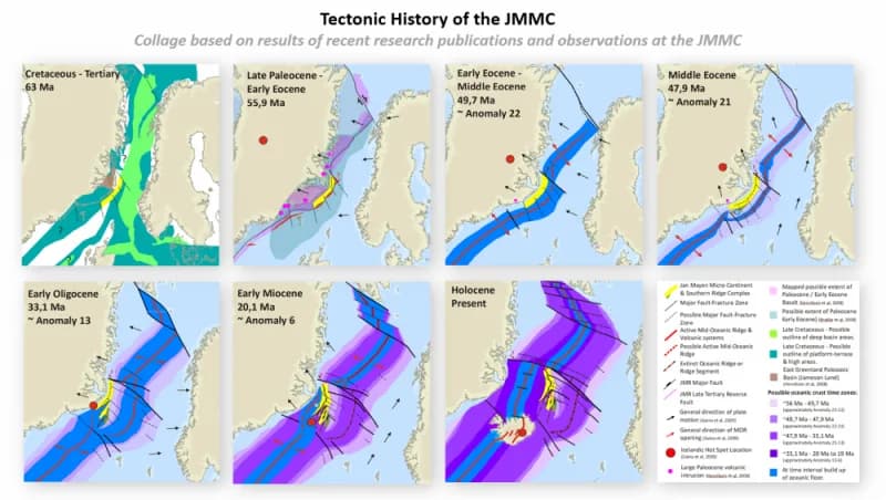
ÍSOR's expert advice to the authorities was aimed, among other things, at investigating the geology of the Jan Mayen Ridge. That research assessment is taken into account when the likelihood of oil in the Dreki area is evaluated. With geological and geophysical data it is possible to trace the geological history of the Jan Mayen area. It is considered to have an affinity with sedimentary basins in East Greenland, the continental shelf of West Norway and the continental shelf of the Faroe Islands and Shetland. In those areas oil has been found in producible quantities.
The results of research bear witness to sedimentary layers that formed before the North Atlantic opened and could possibly date all the way back to the Palaeozoic. A thick sequence of possible sediment can be seen mainly under the western slopes of the area in the Jan Mayen Basin. Such a sedimentary sequence is a prerequisite for a possible hydrocarbon system.
In seabed samples from the Jan Mayen area, indications have been found of oil seepage from the Jurassic period in the vicinity of one of the large fault belts. The samples were taken in the year 2011. These are considered positive indications of a possible hydrocarbon reserve in the area. Gas is considered more likely in deep-lying areas and where volcanic activity has been present. The possibilities of finding oil are considered to be in the shallower slope areas.
Research and mapping will be continued at ÍSOR in collaboration with the University of Iceland. Attention will be directed in particular at the Jan Mayen continental plate. That research is linked to investigations that have been carried out in Greenland, Norway and Britain. The purpose is to increase knowledge of the nature of the structure and sediment formation in the area. There are plans to use the research as a basis for further studies on the distribution of hydrocarbon compounds.
Lectures from conferences on petroleum research
- Seismic volcano-stratigraphic characteristics of the Jan Mayen Micro-Continent area and the possible distribution of volcanic intrusion complex and hydrothermal vents Lecture by Anett Blischke at the 4th Faroe Islands Exploration Conference in Tórshavn, 1–2 May 2012
- Second Icelandic Licensing Round – Jan Mayen Offshore Exploration A Status Update Lecture by Anett Blischke at the APEXX 2012 conference in London, 6–8 March 2012
- Offshore geo-hazards to keep in mind during prospecting and exploration activities of the Jan Mayen Micro-Continent area Lecture by Anett Blischke at the winter meeting of Nordic geologists in Reykjavík, 9–12 January 2012
- Lecture by Anett Blischke at the AAPG 3P Arctic 2011 conference in Halifax, 30 August – 2 September 2011
- Lecture by Anett Blischke at the APPEX 2011 conference in London, 1–3 March 2011
See further on the website of the National Energy Authority (Orkustofnun).